| The
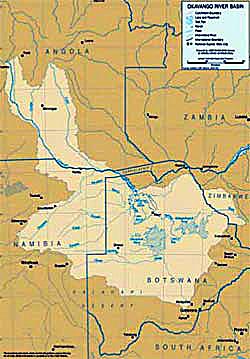
Okavango River Basin The
Okavango basin is one of the world’s natural jewels. It is an almost completely
untouched and truly unique ecosystem which inspires a great deal of emotion in
both local inhabitants and external groups who fight to preserve it. It is also
the only perennial source of water for two growing and exceedingly arid nations,
Namibia and Botswana. The former, desperately short of water, wants to further
develop the river and divert water to meet the needs of its population; the latter
also needs to increase its outtake, but has a very strong economic incentive to
preserve the beauty of the Okavango delta – tourism. The main objective of
this project is to explore the possibility of sharing benefits between Namibia
and Botswana as a catalyst for peaceful development of the water resources of
the basin. Central to this is determining whether Botswana would in any way be
receptive to the concept of sharing certain benefits of tourism with Namibia in
return for Namibia reducing its claim on the water. In short, Green Cross will
strive to act as honest brokers, and if necessary mediators, with the sole objective
of creating an environment in which fair and equitable solutions can be negotiated
between the relevant role-players. The project will also help provide an objective
assessment of the needs and positions of the riparian states which could be useful
in the negotiation process. Conflict prevention measures are essential if serious
disputes are to be avoided when the next drought hits the region. Background
The Okavango River Basin is unique in many regards, not least of which is the
fact that it is the largest endoreic river system in Southern Africa, discharging
into the sands of the Kalahari Desert rather than into an ocean as most rivers
do. The approximate annual streamflow of around 11 bcm enters the Okavango Delta
where around 96% of the water evaporates. What is left flows into the Makgadikgadi
Salt Pans during periods of high flood via the Thamalakane and Boteti Rivers where
it also evaporates, leaving behind a deposit of soda and driving a unique aquatic
ecosystem in a desert setting. The
river basin rises in the Angolan highlands, flows for more than 600-km from the
upper catchment in a southerly direction until it reaches the border between Angola
and Namibia, from where it flows in an easterly direction. From that point it
forms the border between the two countries for a distance of some 400-km. It then
swings southwards again and becomes the only perennial river to actually run across
both Namibian and Botswana soil. (All other perennial rivers, with the exception
only of the Okavango, are found on the borders of both Namibia and Botswana).
The short reach of the river on Namibian soil is generally characterized by flat
terrain, with no natural features that can be used to develop a deep storage dam.
The river then crosses into Botswana where it enters the Okavango Delta and subsequent
Makgadikgadi Pans system from which all of the water evaporates. The mean annual
runoff (MAR) at Mohembo, close to the border between Namibia and Botswana, is
in the order of 10 000 mcm. The total basin area is approximately 120 000 km2,
mostly found in Angola, which is a water-abundant country. The Okavango Delta
covers some 5 000 km2 (a figure that is contested) providing a large surface area
in a geographic location that has a high evaporative demand. A portion of the
basin, notably that feeding into the Makgadikgadi complex originates in Zimbabwe
and is fed via the Nata River. Very
little is known about the water use in the upper catchment, because the Angolan
civil war has prevented any baseline data from being collected. As far as is know,
there is no meaningful development in the upper reaches of the basin, and what
development there was has in most likelihood been severely damaged during the
ongoing military action. Ironically, a possible peace dividend will be the development
of the upper basin, which in turn will negatively impact on one of the last pristine
river systems in Africa. The development of any dams will alter the pulsed nature
of the flooding, with detrimental environmental effect in the Delta. Agricultural
runoff will change the nutrient loads, impacting on one of the basic elements
of the aquatic ecosystem functioning in the Delta. In short, the Okavango River
Basin offers unique developmental challenges as a result of this.
In the middle reaches of the river, a small dam has been built on the Omatako
River, from which water is diverted for domestic and industrial purposes in the
Okahanja-Windhoek complex, which lies in the Swakop River Basin in central Namibia.
There is a major water transfer scheme called the Eastern National Water Carrier
(ENWC) that is strategically important to Namibia. A planned component of the
ENWC (Phase 4) is a pipeline that will abstract 17 mcm/yr from the Okavango at
Rundu. Without this water, the Namibian economy could be seriously affected. Although
Namibia has the legal right to develop this pipeline, and also has the moral right
to use water to develop vitally important socioeconomic activities, this proposed
pipeline is being hotly contested by Botswana. There are also a number of major
international interest groups that support Botswana in this action, making the
development of this pipeline potentially unviable. There was also a mooted hydroelectric
plant at the Popa Rapids in Namibia. Given the flat terrain and resultant low
head, the project would have resulted in significant environmental impacts for
a limited energy yield and has since been abolished. Current data shows that Namibia
uses approximately 5 mcm/yr from the Okavango River. Of this, 41% is for domestic
use, 56% is for agricultural activity including both large and small-scale irrigation,
while the remaining 3% is used for tourism. This data excludes water abstractions
directly from the river or adjacent aquifers for subsistence use by the numerous
human settlements that characterize the area.
In the lower reaches of the river, there is limited infrastructural development
other than the Mopipi Dam, which was constructed on the sub-catchment of the Putimolonwane
Pan. The purpose of the Mopipi Dam is to provide water to the Orapa Diamond Mine,
which is a strategically important development in Botswana. Given the fact that
the Okavango Delta flows into the Kalahari Desert, there is a heavy concentration
of people and general farming activity (mostly beef ranching for export to the
EU market) around the Delta. A limited volume of the river water is used for irrigation
purposes in the Shakawe area of Botswana. This is for the irrigation of 25 hectares
of vegetable crops and is under examination to test the feasibility of expanding
this operation to 125 hectares. There is heavy reliance on groundwater for various
uses in Botswana. The linkage between surface and groundwater is not fully understood,
but it is generally believed that groundwater in parts of the Kalahari is derived
from surface flows in the Okavango Delta region. Small pipelines do exist along
the panhandle, feeding water by gravity to various settlements for domestic and
animal watering purposes. Existing data shows that Botswana uses some 4 mcm/yr,
mostly in the Ngamiland area. This is abstracted directly from either the river
and associated wetlands, or from wells that are fed by the Okavango system. There
is a plan, which has recently been registered with the SADC Water Sector Coordinating
Unit (SADC-WSCU), to develop an international inter-basin transfer from the Zaire
River in the Democratic Republic of Congo, via Angola, to be discharged into the
headwaters of either the Okavango or Kunene Rivers. The pre-feasibility study
of this project has recently gone out to tender. It is expected that this project
will have significant environmental impacts on the Delta, with the potential importation
of alien biota and pathogenic organisms into a relatively pristine and rather
unique aquatic ecosystem, so it is likely to be strongly opposed by environmental
interest groups once they hear of the planning. This proposed project also indicates
to what extent Namibia will go in order to secure a strategic supply of water.
Socioeconomic data is generally poor for the whole basin. The Namibian and Botswanan
portions have been studied however, most notably as the result of the environment
impact assessment (EIA) that was commissioned for the proposed Rundu - ENWC pipeline
in Namibia. Some 100 000 people gain their livelihoods from the river and its
associated wetlands on the Namibian side. This area offers one of the few truly
habitable parts of Namibia and is thus heavily settled. The Ngamiland area in
Botswana has a population of approximately 90 000 people, with a further 25 000
people living around the Delta itself. Tourism is a major source of foreign revenue
for Botswana, and a large number of game lodges and tourist camps are located
in and around the Delta. On any given day in Botswana there are normally more
foreign tourists than local citizens, giving an indication of the magnitude of
tourism in that country. One of the major tourist attractions is the near-pristine
Okavango Delta and related game reserves.
| |
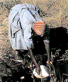
| Collection of water directly from
the river | | | International
Agreements Currently in Place in the Okavango Basin
Bilateral talks between
Namibia and Botswana led to the establishment of the Joint Permanent Water Commission
(JPWC) in November 1990. This coincided roughly with the independence of Namibia
a few months earlier and the cause-effect linkage between these two events has
not yet been firmly established. JPWC focus is on the bilateral management of
the Okavango River and the Kwando-Chobe-Linyati reach of the Zambezi River, both
of which are the only water-rich areas of Namibia and Botswana respectively. The
Chobe-Linyati area is the location of the contested Kasikili/Sedudu Island that
saw shots being fired and military forces being mobilized at one time. This dispute
has recently been settled in Botswana's favour by the International Court of Justice
(ICJ). There is also a limited but significant secessionist movement in the Caprivi
Strip, creating a localized pocket of political instability with the potential
of being destabilized by the close proximity of the Angolan civil war, with the
free movement of people and military materiel in that immediate area exacerbating
the problem. This has given rise to the belief that a water-related conflict is
likely to arise in this area in future if river basin management is not effective.
Subsequent discussions launched in 1992 between Namibia, Botswana and Angola led
to the formation of the tripartite Permanent Water Commission on the Okavango
River in 1994. This is known as OKACOM and is generally functioning satisfactorily
despite the highly visible and hostile public exchange that occurred as a result
of Namibian plans to build the Rundu-ENWC pipeline that were announced during
the drought that coincided with Namibian independence. Tempers seem to have cooled
since then and relations have become more cordial over time. The ICJ ruling on
the Kasikili/Sedudu Island Dispute has also tended to sober up the various role-players,
showing that negotiated solutions are better than heated conflict, whether in
or out of court. This has been enhanced by the fact that the drought has broken
and a cycle of higher than usual precipitation has been the norm during the latter
part of the 1990s. When another drought occurs, again placing the critical need
to secure a strategic supply of water for the economically important Windhoek
area of Namibia under the spotlight, then another outbreak of hostile rhetoric
can be anticipated. Given
the lack of baseline data in the Okavango Basin, coupled with the perception in
the Western world that the conflict potential between Namibia and Botswana is
high as a result of the Kasikili/Sedudu Island dispute and subsequent rhetorical
exchanges over the planned Rundu-ENWC pipeline, the Global Environmental Facility
(GEF) has funded various activities in support of OKACOM. One of these activities
is the imminent trip to the USA by senior OKACOM functionaries, ostensibly to
study the management of contested river basins elsewhere. Another planned activity
is the generation of uncontested baseline data on which to develop future management
strategies. It is important to build trust between the various riparian states.
At present the
workings of OKACOM are considered by key role-players to be satisfactory, although
less informed commentators often claim that relations are strained between Namibia
and Botswana. Angola is water-rich and has a completely different set of developmental
priorities, most of which relate to the ongoing civil war. The fact that the upper
reaches of the Okavango Basin lies in territory that is not controlled by government
forces also mitigates against a stronger Angolan government commitment.
The concept of an International Public Good (IPG) is not well known or understood
by any of the roleplayers in the Okavango River Basin at present, but there is
strong support for the need to improve river basin management at the international
level. There is also a strong need to develop uncontested basin-wide data that
is shared between all riparians that can inform future management strategies.
The cost of managing the river basin at the international level is not fully known
by either role-player.
| |
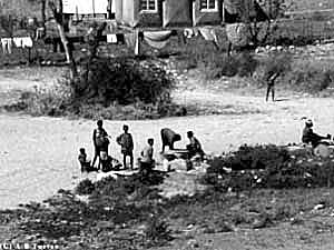
| Population on the banks of Okavango |
| | Main
Problems in the Basin
There are a number of interesting features that make the Okavango Basin unique.
1. It is an endoreic system without any opening to the sea.
2. It represents the only water that flows on Namibian and Botswanan soil, the
two driest countries in the SADC region.
3. There has been an ongoing civil war for more than a quarter of a century in
Angola, the upstream riparian. This has meant that almost no development has taken
place in the upper reaches.
4. The two countries with the highest water resource needs (Namibia and Botswana)
are both downstream riparians. These two countries contribute almost nothing by
way of streamflow.
5. The aquatic ecosystems associated with the Delta and Makgadikgadi Salt Pan
is protected under the Ramsar Convention. This means that any development upstream
will impact on an aquatic ecosystem in which many international special interest
groups have a vested interest. It also means that development options for both
Namibia and Botswana are severely limited by this factor. This in turn raises
the thorny issue of sovereignty in the sense that foreign special interest groups
are challenging the intentions of the legitimate government of each of the downstream
countries.
6. In the river reach where there is the highest need for water (Namibia and Botswana),
there are no natural features that can be used to develop a deep storage facility.
7. The principle of "equitable use" that is central to the Helsinki
Rules has not been defined. The upstream riparian (Angola) has the largest area
of the basin in its territory and it also contributes the majority of the streamflow.
The two downstream countries (Namibia and Botswana) both have a relatively small
surface area in the basin, and generally do not contribute a sizeable proportion
of the streamflow. Does this then mean that their "equitable use" allocation
must be determined by these geophysical parameters? It also raises the controversial
question of rights versus needs. In this case the needs of the downstream riparians
are arguably greater than the upstream riparian, but by virtue of climatic and
geographic conditions, the latter can claim the lion’s share of the water.
8. There is a direct clash of values between competing end-users of water, particularly
between Namibia and Botswana. In
short, the Okavango River Basin is a near-pristine river that flows through a
landscape that is arid and underdeveloped, which means that a high emotional content
exists within the discourse surrounding the potential development of the basin.
Characterisation
and Potential Conflicts
The conflict potential in the Okavango Basin is determined by the following factors:
1. There is a history
of belligerence between Botswana and Namibia over the Kasikili/Sedudu Island.
This belligerence has seen shots being fired and troop movements, but no casualties
have been reported. Matters are made even more sensitive by the secessionist sentiment
in portions of the Caprivi Strip.
2. Angola is a country divided by civil war. The legitimate government of Angola
has no control over the Okavango River basin within Angola. This lies mainly under
the control of the rebel UNITA movement. This in turn means that any decision
that has been made by the Angolan government regarding OKACOM has no real meaning
because UNITA is excluded from the river basin management structures.
3. Namibia is a
water-stressed state with most of its economic development located in the dry
central portion of the country. For this reason a complex set of water transfers
have been developed (ENWC). These transfers are strategically important for Namibia
and are currently stretched to their limits. Namibia therefore needs to augment
supply from the only available source - the Okavango River.
4. Botswana is also water-stressed. The Okavango Delta is both a centre of population
settlement and economic activity, mostly from international tourism. The perception
in Botswana is that Namibian developments woud impact negatively on the Delta.
Botswana consequently opposes the Namibian development on the grounds that reduced
streamflow to the delta would have a detrimental impact on social and ecological
processes. Yet while this is the publicly stated position, Botswana is quietly
developing a series of pipelines along the Panhandle. These will supply existing
settlements, and will also act as a strong migration- pull factor in the future.
5. Botswana has declared the Okavango Delta as a Ramsar Site. This has given it
protection, but has also made future development subject to the approval by a
number of international role-players, such as environmental NGOs that are located
outside of the Region. This has introduced a strong international dimension into
the already complex hydropolitical dynamics of the basin. Objectives
The main objective of this project is to explore the possibility of sharing benefits
between Namibia and Botswana as a catalyst for peaceful development of the water
resources of the basin. Central to this is determining whether Botswana would
in any way be receptive to the concept of sharing certain benefits of tourism
with Namibia in return for Namibia reducing its claim on the water. In short,
GCI will strive to act as honest brokers, with the sole objective of creating
an enabling environment in which fair and equitable solutions can be negotiated
between the relevant role-players. Measurable
Results
• Two
workshops will be held in which all of the basin-wide role-players will be invited
to participate. The workshops will be co-organised with the IUCN, who are very
active in Botswana. This workshop will establish a mutually agreed set of objectives
including evaluating various decision support methodologies. The second workshop
will act as a preparatory meeting for the forthcoming 3rd World Water Forum (WWF).
•
The work that is currently being done by GEF will be supported wherever possible.
As such GCI will become one of the supporting elements of the existing GEF initiative.
•
The development and publishing of a written report on the hydropolitical dimensions
relevant to the Okavango River Basin, including the concerns and recommendations
identified at the workshops. This will enable each individual element of the conflict
/ potential conflict to be contextualized with great accuracy and clarity, and
will be a useful guide for future negotiations between the riparian states.
Activities
to be Implemented
• An initial
scoping study will be made by AWIRU. This study will be done in conjunction with
other role-players and will provide more details concerning the various steps
in the overall programme.
•
An initial workshop will be held in the Okavango River Basin at a venue to be
decided. This could also be jointly coordinated with the IUCN. Consensus will
be obtained on the way forward, which will be the output of this workshop.
• A detailed study will be launched on the hydropolitical
dimensions. This will result in a written report that will be presented at the
second workshop.
• Special interventions will be made by GCI as appropriate; GCI and IUCN
could coordinate mediation between Botswana and Namibia in order to prevent future
disputes when the next drought arrives.
•
A second workshop will be arranged at a venue to be determined. The hydropolitical
report will be presented for comment from all sides. The technological aspect
of water savings will also be discussed. Progress will be evaluated and a draft
document will be generated. This draft document will become the basis for the
official report that will be tabled by GCI at the 3rd WWF.
Project
Partners •
GCI will act as the overall co-ordinating body, linking the Okavango Project to
the other basins that are part of the Water for Peace project. •
The African Water Issues Research Unit (AWIRU) at Pretoria University will be
responsible for the hydropolitical analysis. •
The 3rd WWF will provide the global platform needed to gain support for the various
actions. •
The IUCN will provide necessary support in terms of environmental issues and identification
of role-players, as well as assisting in coordinating the two workshops. •
The United Nations University (UNU) in Japan has knowledge about shared rivers
in Southern Africa as the result of its past involvement in the Zambezi River
Basin. In particular Prof. Miki Nakayama's knowledge of institutional affairs
will be needed to make the project a success.
• ENVIRONMENTEK at the Council for Industrial and Scientific Research (CSIR)
in Pretoria will provide the necessary scientific support needed.
• OKACOM is the official transnational structure that is responsible for
developing a management plan for the Okavango River Basin. •
GEF is an existing agency that is active in the support of OKACOM. •
The governments of the riparian states are key roleplayers, mostly through their
respective Departments of Water Affairs. •
The SADC Water Sector is the regional structure responsible for supporting River
Basin Organizations such as OKACOM. |